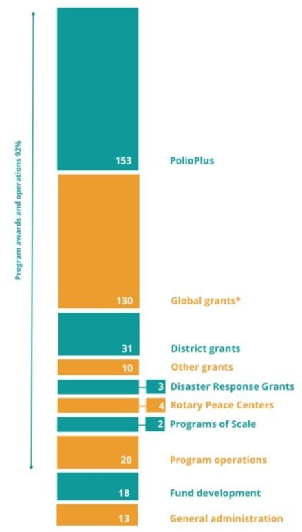
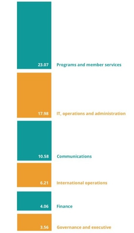
Polio mapping goes high tech
Geotracking ensures fewer children are left behind

Sandrine Lina (left) and other vaccinators hit the streets with cellphones that tracked their progress during an outbreak response campaign in the Republic of Congo.
Image credit: Marta Villa Monge/WHO Africa Office
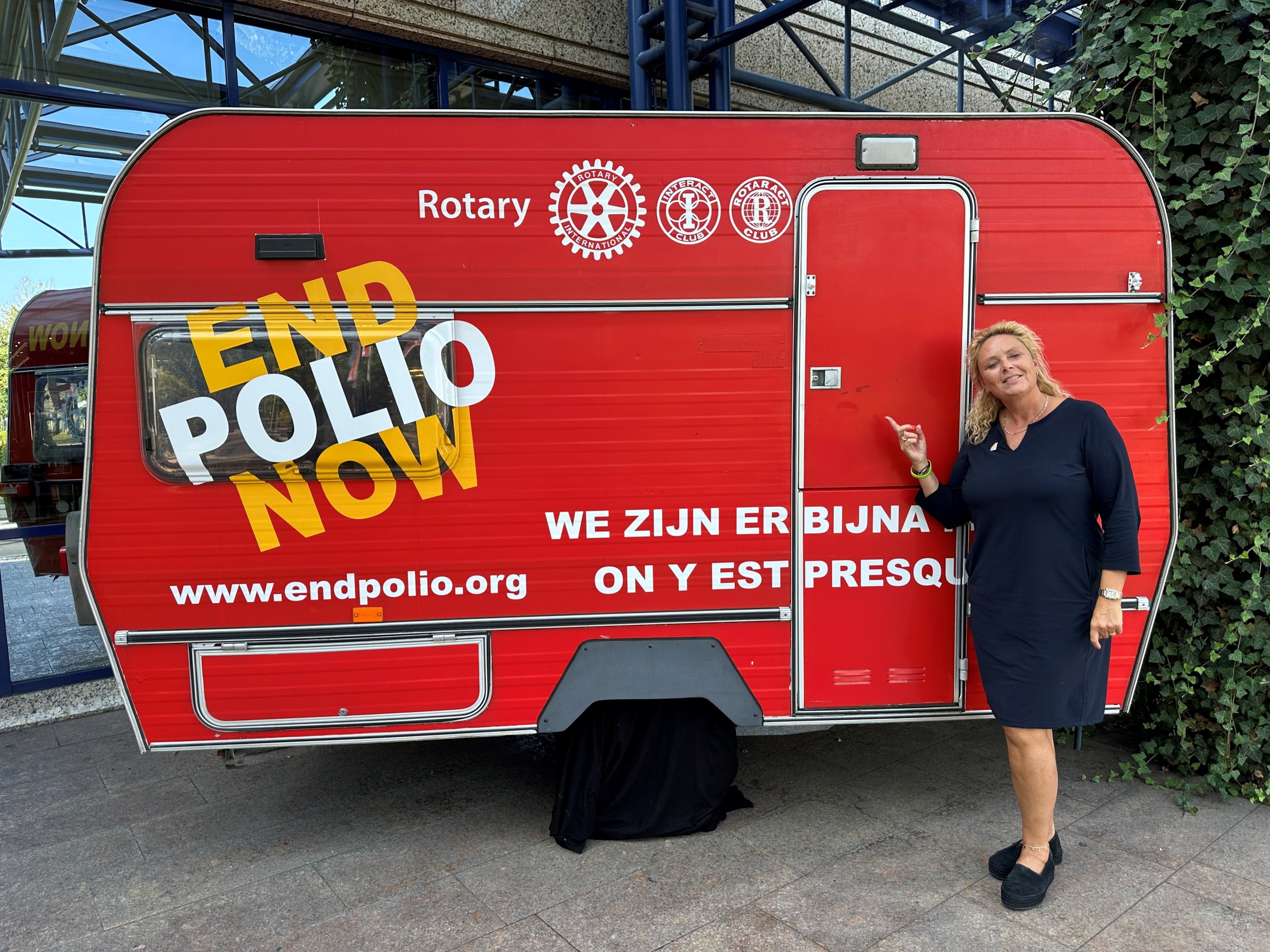
When polio vaccinators fanned out across areas of the Republic of Congo last year to stop an outbreak, they carried a powerful new tool in their pockets: cellphones that tracked their progress as they went door to door. Equipped with a mobile app, the phones sent data back to a command center where staff could see on a digital map if homes were missed and redirect teams on the ground.
With support from the World Health Organization and other partners in the Global Polio Eradication Initiative, the country is helping pioneer the use of what is known as geospatial tracking to stop polio outbreaks. Instead of relying on hand-drawn maps that are prone to errors, response team leaders can see with pinpoint accuracy where vaccinators have been and which homes they didn’t get to. This happens in real time when a wireless connection is available. Such speed and precision are crucial to ensuring that a vaccine reaches each child and outbreaks are stopped.
“All you have to do is charge your phone and make sure you turn on the tracker when you are out on the streets. I just put it in my pocket and go from house to house,” says Sandrine Lina, one of the WHO-trained vaccinators.
She and others hit the streets in June 2023 with hundreds of the phones after an outbreak of variant poliovirus type 1. The WHO African region was certified free of wild poliovirus in 2020. But this other form of polio, known as vaccine-derived or variant poliovirus, remains a threat. These cases occur in rare instances when the live but weakened virus in oral vaccines circulates long enough through sewage in communities with low vaccination rates to mutate into a potentially dangerous form.
The key to stopping such outbreaks is a thorough vaccination campaign. Geospatial tracking is playing a crucial role, generating intelligent maps and models. “The platform provides an opportunity for us to identify settlements that have poor coverage, where we’ve not seen many tracks of vaccination teams, and we can download the information to guide processes,” says Kebba Touray, the lead of WHO’s Geographic Information Systems Centre for the African region.
An early generation of the technology was used in Nigeria beginning in 2012, helping lead to the region’s certification as free of wild poliovirus eight years later. “That’s what gave birth to this innovative idea of ensuring settlements are mapped,” Touray says. It’s also been used in Cameroon.
For the June vaccination campaign, led by the Republic of Congo’s Health Ministry, about 500 smartphones were distributed each morning to vaccinators. Like a fitness tracker, the mobile app counts steps and plots the coordinates on a map, along with essential details such as dates and times. Vaccinators also can use the phones to collect field data such as settlement names, household information, and reasons given by those refusing a vaccine.
That information feeds a database that operations center managers can supervise in real time. It’s displayed on an online dashboard through a heat map that shades areas in green and red hues. “Green indicates that vaccinators have passed in these areas, and red areas indicate that, Oh, these areas were planned, but no team passed through,” explains Derrick Demeveng, a data and geographic information systems analyst who worked with the vaccination response team.
At the end of the first day, the operations center team in the capital, Brazzaville, saw that a section of the city’s Poto-Poto district had not been covered. Vaccinators were sent there first thing in the morning to find any children who had been missed.
That ability to review data and make quick course corrections is critical. In the past, planners had to rely on maps drawn by vaccinators to prepare what are known as microplans. Inaccuracies were inevitable, and information often wasn’t verified until after the campaign had ended. “The microplan is the critical component in preparing for outbreak response campaigns. You have to know where all the settlements are,” Touray says.
Disease mapping in response to public health emergencies has a long history. In 1854, English physician John Snow pioneered one of the earliest uses of mapping in modern epidemiology during a cholera outbreak in London. In search of a pattern, Snow mapped cases and — because he believed contaminated water was to blame — the locations of water pumps, and he found a connection. He was able to identify a single pump as the likely primary source, and when it was closed the outbreak ended.
Today, with a lot of computing power behind it, geospatial analytics is used in everything from weather modeling and sales trend forecasting to national defense, disaster response, and agriculture. The WHO is using geospatial technology to counter public health threats across the globe, from saving people in India from snake bite deaths to COVID-19 vaccine delivery in over 90 countries to polio eradication.
Geospatial technology is important for reaching members of communities who are often overlooked, says Rufaro Samanga, an epidemiologist who works at the Bill & Melinda Gates Foundation, another GPEI partner. “Immunizations would be better served, especially in low- to middle-income countries, where you’re already dealing with limited resources in some settings. Real-time data from these tracking systems allows us to identify parts of the population that are often missed,” Samanga says.

Like a fitness tracker, the mobile app counts steps and feeds coordinates to a map, viewed at a command center (below) where staff members can see if homes were missed.
Image credit: Marta Villa Monge/WHO Africa Office
The newest version of the technology, used in the Republic of Congo, has many improvements. “This one is lightweight, it’s easy to deploy,” Touray explains. “And you are able to collect field information, especially concerning settlements, and to ensure that whatever information you are able to collect during an outbreak response campaign, you go back and use it to update your microplan” for future campaigns.
Demeveng says the technology solves the challenge of on-field visibility and incorporates a system of accountability, with supervisors able to monitor, direct, and advise vaccinators in the field. When they return to the emergency operations center, an analysis of the day’s outing is carried out.
While the Republic of Congo project was deemed successful, it did brush up against a familiar challenge: the digital divide. Despite advancements in digital inclusion, 2.6 billion people around the world remain unconnected to the internet, a considerable share of them in Africa, according to one recent analysis.
And a lack of strong internet infrastructure often disrupted the real-time upload feature of the geospatial tracking app. But the technology and the data collection are filling in the picture of polio and other public health challenges.
Touray and his WHO African team plan to implement these tracking systems elsewhere on the continent, including for purposes beyond polio. With the introduction of new technologies, though, one thing hasn’t changed: All vaccinated children are still marked on a finger with ink they can proudly display.
This story originally appeared in the March 2024 issue of Rotary magazine.
Visit :-
https://www.rotary.org/en/polio-mapping-goes-high-tech